
 |
|
||||||||||
 |
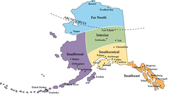
SOUTHCENTRAL, ALASKA ANCHORAGE - MATSU VALLEY - KENAI PENINSULA |
||||||
The City of Anchorage (click on link to see details) is the State's principal population center. Anchorage is surrounded by the saltwaters of Cook Inlet. To the North of Anchorage lies the Matsu Valley with the towns of Wasilla and Palmer. To the South of Anchorage you will find the Kenai Peninsula Borough which includes the towns of Seward, Soldotna and Homer. The waters of the Gulf of Alaska and Prince William Sound border the borough on the south and east with the dramatic mountains of the Alaska Range rimming the borough to the west. The Cook Inlet divides the borough into two land masses. Home prices on the Kenai Peninsula are some of the best bargains at present in all of Alaska. Rental rates for homes and cabins on the Kenai are also very reasonable as compared to other areas of Alaska. |
|||||||
The Kenai Mountains run north and south through the peninsula, contrasting to the lowlands lying to their west. The west side of the Inlet is sparsely inhabited, with the native village of Tyonek being the largest populated settlement. The boundaries of the borough encompass a total of 25,600 square miles, of which 15,700 square miles are land. In comparision, the total land mass of the borough equals that of Massachusetts and New Jersey combined. However, the total borough population is less than 1/400th of that same area. The rivers of the Kenai Peninsula contain all 5 species of wild salmon.You can have wild Alaskan salmon fillets shipped direct to your door from the Kenai Peninsula by clicking here. The Kenai Peninsula and the Kenai River are world reknown for fabulous fishing and a wide range of real Alaskan outdoor adventures. |
|||||||
ALASKA FACTS: |
|||||||
Admitted to Statehood: January 3, 1959 Capital: Juneau Nicknames: Great land and Last Frontier Motto: "North to the Future" Bird: Willow Ptarmigan Fish: King Salmon Flower: forget me not Gem: Jade Tree: Sitka Spruce Song: "Alaska's Flag" |
 |
||||||
Origin of Name: Russian version of an Aleutian word, Alakahak, for "peninsula," "great lands," or "land that is not an island" The U.S. bought Alaska from Russia in October 1867 for 7.2 million dollars, or two cents per acre. Many Americans thought this was a waste of money and called Alaska "Seward’s Folly," after Secretary of State William H. Seward who arranged the purchase. Alaska longest river, the Yukon, runs about 2,300 Miles, 1,400 in Alaska and 900 in Canada. Each year Alaska has approximately 5,000 earthquakes, including 1,000 that measure above 3.5 on the Richter scale. Of the ten strongest earthquakes ever recorded in the world, three have occurred in Alaska. Of the nation's 20 highest mountains, 17 are in Alaska. Mount McKinley ( 20,320 feet ) in the Alaska Range The National Park Service oversees more than 50 million acres of Alaska land. Six million-acre The Iditarod Trail Sled Dog Race, know Alaska Extremes: the coldest day ever recorded: minus 80 degree's F at Prospect Creek Camp, Jan.23, 1971.The hottest day: 100 degree's F at Fort Yukon, June 27, 1915. The deepest single snowfall ever recorded in Alaska: 62 inches, Thompson Pass, Dec. 7, 1955. Alaska has more than 5,000 glaciers covering 100,000 square miles. There are more active glaciers and ice fields in Alaska than in the rest of the inhabited world. The largest glacier is the Malaspina at 850 square miles. Five percent of the state, or 29,000 square miles, is covered by glaciers. Alaska boasts the northernmost (Point Barrow), the easternmost (Semisopochnoi Island in the Aleutians), and the westernmost (Little Diomede Island) points in the United States. This is possible because Alaska straddles the international dateline. On March 27, 1964, North America’s strongest recorded earthquake, magnitude 9.2 on the Richter scale, rocked central Alaska. |
|||||||
See more Alaska and Yukon maps and travel information >>>.
Home |
|||||||
